
The Legend of Kunibiki
From Izumo-no-kuni Fudoki
One day, the god Yatsukamizuomizunu was muttering to himself, “This nation of Izumo has just been created, and it is incomplete. The land is narrow and cramped. When the gods made this land, they made it too small. I shall find some extra land to add on here.”
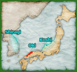
Then, after looking across the sea to the land of Shiragi, he said, “There’s some spare land on the cape over there.” Grasping his plow, which was as wide as a young maiden’s breasts, he drove it into the land, as one would stab a large fish in the gills. Then, like one would cut apart that fish meat, he dug up the land and tied a large, strong rope to it. Then, like one would haul in frostbitten vines or gently, quietly pull a riverboat upstream, saying “Kuni ko (Land, come here), Kuni ko,” he pulled the land over to Izumo and added it on to the rift west of Kozu to make the land of Kizuki. The stake he used to hold the rope became Mt. Sahime, which towers above its surroundings on the border of Izumo and Iwami, and the rope itself, became the coastline of Sono-no-Nagahama.
Next, after looking north across the sea to the area called Saki in the land of Oki, he said, “There’s some spare land over there, too.” Once again taking his plow, he sliced off that land and pulled it to Izumo, adding it on to the rift west of Taku to make the land of Sada.
Next, he said, “I also see some spare land in the area of Yonami in the land of Oki.” Again, he cut off that land and pulled it to Izumo, adding it on to the rift west of Unami to make the land of Kurami.
Then, after looking across the sea to the cape of Tsutsu in the land of Koshi, he said, “There’s some spare land there, too.” He cut of this land and pulled it to Izumo as well, adding it on to make the land of Miho. The rope he used became the island of Yomi, and the stake he used to hold the rope became Mt. Hinokami in the land of Hoki.
He surveyed his work and was satisfied. “I am finished pulling land here.” Then taking his staff and driving it into the ground, he shouted “Oye!” (“That’s a job well done!”). It is likely that, over time, "Oye" gradually changed to "Ou", which is why that area is now named Ou.
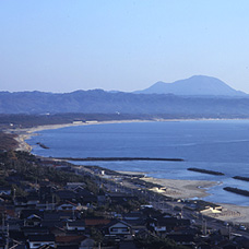
Inasa-no-Hama beach is part of Sono-no-Nagahama, which is said to be one of the ropes holding the Shimane Peninsula in place.
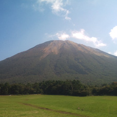
Mt. Daisen, in western Tottori, is said to be the stake used to hold the eastern part of the Shimane Peninsula in place.
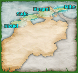
Visiting Locations featured in the Legend of Kunibiki
For starters, this myth describes how the entirety of the Shimane Peninsula was formed. The rope that became Sono-no-Nagahama is the beach that stretches along the west coast of Izumo City, and the stake that held it in place, Mt. Sahime, is Mt. Sanbe in Oda City. The rope that became the island of Yomi is Yumi-ga-hama, a peninsula that runs from Yonago out to Sakai Minato. Long ago, that area was only an island unconnected to the mainland, but geographic changes over time have caused it to form that peninsula. The stake that held the island of Yomi in place, Mt. Hinokami, is Mt. Daisen in Tottori Prefecture. The staff that Yatsukamizuomizunu drove into the ground in Ou is said to have grown into a forest, and a solitary tree that stands out among the rice fields in the Chikuya area of Matsue is said to be what remains of that forest.
The new lands Yatsukamizuomizunu made are all parts of the Shimane Peninsula. Kizuki is the westernmost part of the peninsula, and it is the area where Izumo Taisha is located. Sada is the Hirata area of Izumo and Kashima area of Matsue. Kurami is the northern part of Matsue City, including areas of the Kashima and Shimane towns, and Miho is the easternmost part of the peninsula, where the Mihonoseki area of Matsue is located.
The other areas mentioned in this myth are also real places. Shiragi refers to the eastern part of the Korean Peninsula that was known long ago as the nation of Silla. Saki and Yonami were both areas of the Oki Islands, and Koshi was the name for the Hokuriku Region in Japan (Niigata, Toyama, Ishikawa, and Fukui Prefectures). It is said that the specific area of Koshi referred to here, Tsutsu, is the Noto Peninsula in Ishikawa Prefecture.
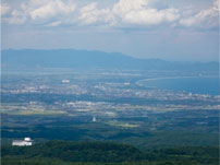
The Shimane Peninsula itself is an odd geographic feature of Shimane: a group of low-lying hills that rise quickly up from the Hikawa Plain and then drop off into the Sea of Japan. Looking at this area from higher up, like from the scenic viewpoints on Mt. Sanbe or Mt. Daisen, you can see how the land looks and even visualize how a myth like this could come to be.
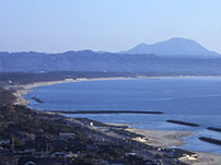
Sono-no-Nagahama
Kizukikita, Taisha-cho, Izumo City, Shimane
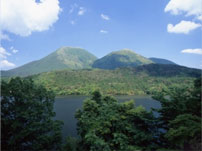
Mt. Sahime
Mt. Sanbe
Sanbe-cho, Oda City, Shimane
Yumi-ga-hama
This peninsula ranges between Yongao City and Sakaiminato City.
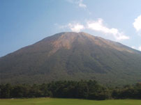
Mt. Hinokami
Mt. Daisen
Daisen-cho, Saihaku-gun, Tottori
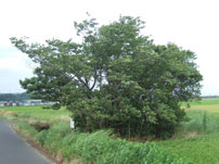
Ou
Chikuya-cho, Matsue City, Shimane